Beyer Matthias

and 9 more

The spatial variation of soil water isotopes (SWI) - representing the baseline for investigating root water uptake (RWU) depths with water stable isotope techniques - has rarely been investigated. Here, we use spatial SWI depth profile sampling in combination with unmanned aerial vehicle (UAV) based land surface temperature estimates and vegetation indices (VI) in order to improving process understanding of the relationships between soil water content and isotope patterns with canopy status. We carried out a spatial sampling of ten SWI depth profiles in a tropical dry forest. UAV data were collected and analyzed to obtain detailed characterization of soil temperature and canopy status. We then performed a statistical analysis between the VI and land surface temperatures with soil water content and SWI values at different spatial resolutions (3 cm to 5 m). Best relationships were used for generating soil water isoscapes for the entire study area. Results suggest that soil water content and SWI values are strongly mediated by canopy parameters (VI). Various VI correlate strongly with soil water content and SWI values across all depths. SWI at the surface depend on land surface temperature (R² of 0.65 for δ18O and 0.57 for δ2H). Strongest overall correlations were found at a spatial resolution of 0.5 m. We speculate that this might be the ideal resolution for spatially characterizing SWI patterns and investigate RWU. Supporting spatial analyses of SWI with UAV-based approaches might be a future avenue for improving the spatial representation and credibility of such studies.
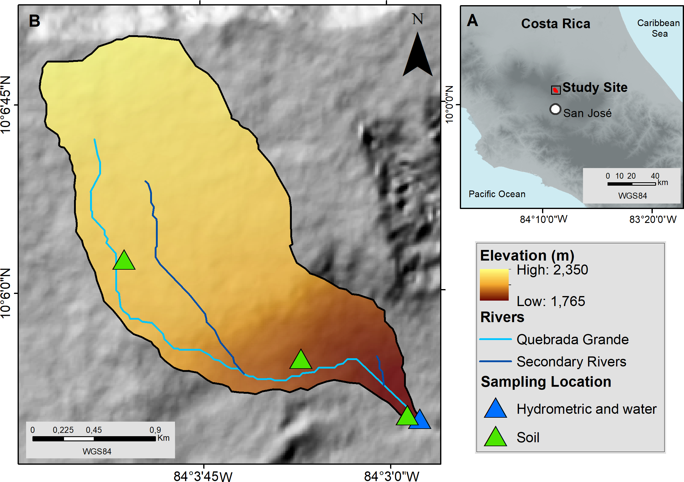
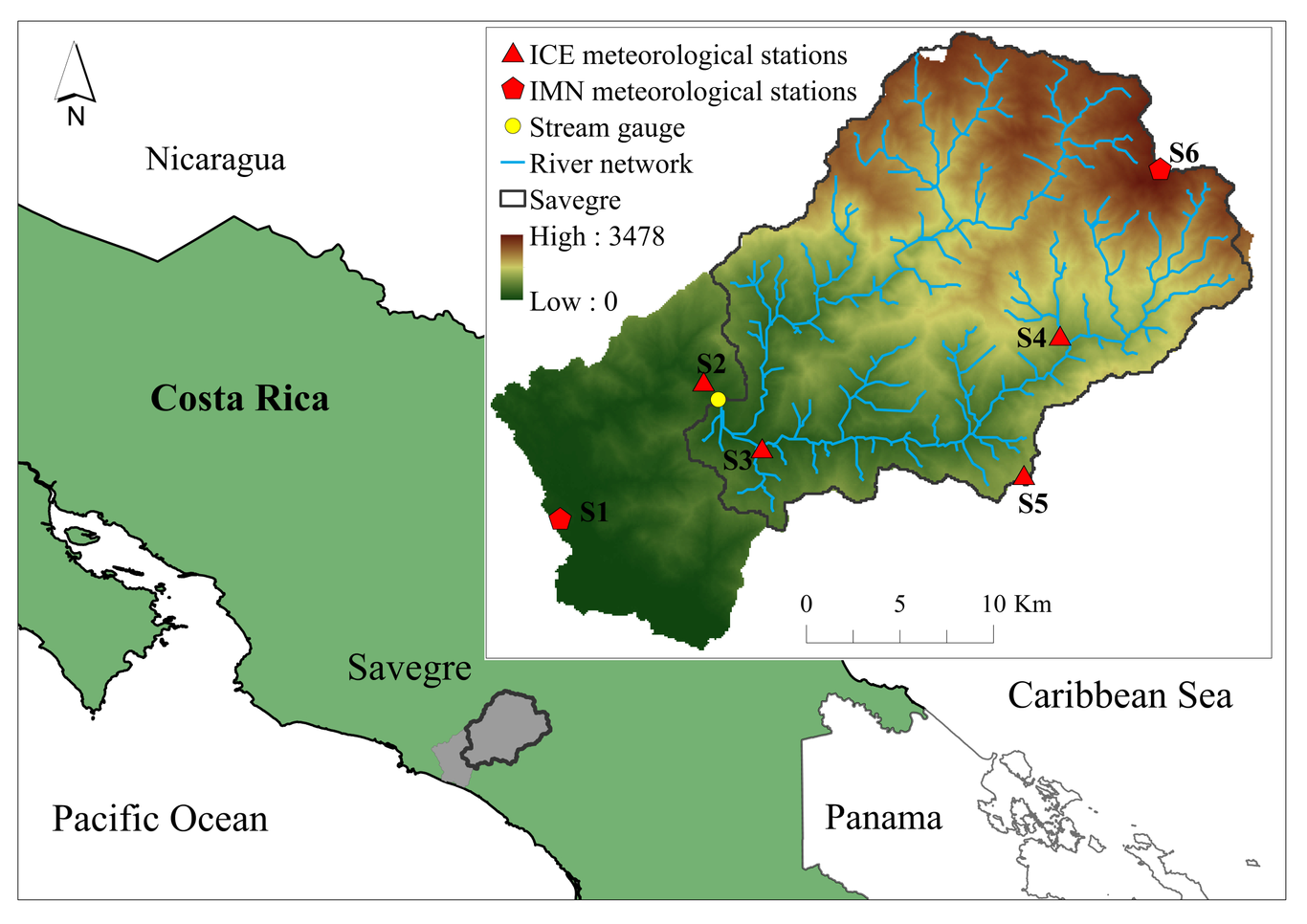
The El Niño-Southern Oscillation (ENSO) phenomena, originating in the tropical Pacific region, is an interannual climate variability driven by sea surface temperature and atmospheric pressure changes that affect weather patterns globally. In Mesoamerica, ENSO can cause significant changes in rainfall patterns with major impacts on water resources. This commentary presents results from a nearly 10-yr hydrometric and tracer monitoring network across north-central Costa Rica, a region known as a headwater-dependent system. This monitoring system has recorded different El Niño and La Niña events, as well as the direct/indirect effects of several hurricane and tropical storm passages. Our results show that ENSO exerts a significant but predictable impact on rainfall anomalies, groundwater recharge, and spring discharge, as evidenced by second-order water isotope parameters (e.g., line conditioned-excess or LC-excess). The Oceanic Niño Index (ONI) is correlated with a reduction in mean annual and cold front rainfall across the headwaters of north-central Costa Rica. During El Niño conditions, rainfall is substantially reduced (by up to 69.2%) during the critical cold fronts period, subsequently limiting groundwater recharge and promoting an early onset of baseflow conditions. In contrast, La Niña is associated with increased rainfall and groundwater recharge (by up to 94.7% during active cold front periods). During La Niña, the long-term mean spring discharge (39 Ls -1) is exceeded 63-80% of the time, whereas, during El Niño, the exceedance time ranges between 26% and 44%. These stark shifts in regional hydroclimatic variability are imprinted on the hydrogen and oxygen isotopic compositions of meteoric waters. Drier conditions favored lower LC-excess in rainfall (-17.3‰) and spring water (-6.5‰), whereas wetter conditions resulted in greater values (rainfall=+17.5‰; spring water=+10.7‰). The lower and higher LC-excess values in rainfall corresponded to the very strong 2014-16 El Niño and 2018 La Niña, respectively. During the recent triple-dip 2021-23 La Niña, LC-excess exhibited a significant and consistently increasing trend. These findings highlight the importance of combining hydrometric, synoptic, and isotopic monitoring as ENSO sentinels to advance our current understanding of ENSO impacts on hydrological systems across the humid Tropics. Such information is critical to constraining 21 st century projections of future water stress across this fragile region.

Sánchez-Murillo, R

and 7 more

Tracer-aided studies to understand source water partitioning in tropical ecosystems are limited. Here we report dry season source water partitioning in five unique ecosystems distributed across Costa Rica in altitudinal (<150-3,400 m asl) and latitudinal (Caribbean and Pacific slopes) gradients: evergreen and seasonal rainforests, cloud forest, Páramo, and dry forest. Soil and plant samples were collected during the dry season (2021). Plant and soil water extractions (triplicates) were conducted using controlled centrifugation. Stem water extraction efficiency and stem water content were calculated via gravimetric measurements. Water source contributions were estimated using a Bayesian mixing model. Isotope ratios in soil and stems exhibited a strong meteoric origin. Enrichment trends were detected mainly in stems and cactus samples within the dry forest ecosystem. Soil profiles revealed nearly uniform isotopic profiles; however, a depletion trend was observed in the Páramo ecosystem below 25 cm depth. More enriched compositions were reported in cactus samples for extracted water volumes above ~20% ( Adj. r2=0.34, p<0.01). The most prominent dry season water source in the evergreen rainforest (74.0%), seasonal rainforest (86.4%), and cloud forest (66.0%) corresponded with soil water. In the Páramo ecosystem, recent rainfall produced by trade wind incursions resulted in the most significant water source (61.9%), whereas in the dry forest, mean annual precipitation (38.6%) and baseflow (33.1%) were the dominant sources. The latter highlights the prevalence of distinct water uptake sources between recent cold front’s rainfall to more well-mixed soil moisture during the dry season.

Leia Mayer-Anhalt

and 3 more

There is still limited understanding of how waters mix, where waters come from and for how long they reside in tropical catchments. In this study, we used a tracer-aided model (TAM) and a gamma convolution integral model (GM) to assess runoff generation, mixing processes, water ages and transit times (TT) in the pristine humid tropical rainforest Quebrada Grande catchment in central Costa Rica. Models are based on a four-year data record (2016 to 2019) of continuous hydrometric and stable isotope observations. Both models agreed on a young water component of fewer than 95 days in age for 75% of the study period. The streamflow water ages ranged from around two months for wetter years (2017) and up to 9.5 months for drier (2019) years with a better agreement between the GM estimated TTs and TAM water ages for younger waters. Such short TTs and water ages result from high annual rainfall volumes even during drier years with 4,300 mm of annual precipitation (2019) indicating consistent quick near-surface runoff generation with limited mixing of waters and a supra-regional groundwater flow of likely unmeasured older waters. The TAM in addition to the GM allowed simulating streamflow (KGE > 0.78), suggesting an average groundwater contribution of less than 40% to streamflow. The model parameter uncertainty was constrained in calibration using stable water isotopes (δ2H), justifying the higher TAM model parameterization. We conclude that the multi-model analysis provided consistent water age estimates of a young water dominated catchment. This study represents an outlier compared to the globally predominant old water paradox, exhibiting a tropical rainforest catchment with higher new water fractions than older water.
Understanding how droughts propagate through the hydrological cycle from precipitation to streamflow and groundwater is important for improving water and risk management policies. At the catchment scale, the analysis of drought propagation and classification into drought types is usually done manually, which can be time consuming and difficult to replicate. Here, we developed an automated, objective procedure for classification of different drought types with the aim to study drought propagation in the tropics. The method was applied to the Savegre catchment in Costa Rica as a proof-of-concept. We first confirmed that drought events in the catchment could be classified into the process-based typology from the literature: classical rainfall deficit drought, wet-to-dry season drought, and composite drought. The automation algorithm was able to replicate the classification obtained with the manual typology with the exception of two events, and thus it is a development towards objective and time efficient hydrological drought analysis in tropical catchments. Most of the detected hydrological droughts (80% and 76% of all river discharge and baseflow droughts, respectively) were classical rainfall deficit droughts, which suggests that climate plays a more important role in drought development than catchment characteristics in this catchment. However, the importance of catchment characteristics was revealed by the presence of severe composite drought events and by the attenuation of significant precipitation droughts.

Alicia Correa

and 6 more

The páramos, a neotropical alpine grassland-peatland dominated biome of the northern Andes and Central America, play an essential role in regional and global cycles of water, carbon, and nutrients. They act as water towers, delivering water and ecosystem services mainly from the continental water divide at the Andean highland down to the Pacific and Amazon regions. The anthropogenic influence in form of the climate crisis exerts enormous pressures on these identified “hotspot” ecosystems and increases the vulnerability of nearby populations undermining the socio-economic and human development. Further, increasing pressures reduce the resilience to face climate shocks, and dramatically alters the hydro-climatic regime and shifts the páramos from long-term carbon sinks towards carbon sources. Despite their importance and vulnerability, only three decades ago, páramos, were globally among the least studied ecosystems. However, researchers have since identified them as ideal targets for solving water scarcity issues and to offset carbon emissions. Increasing awareness of the need for hydrological evidence to guide sustainable management of the páramos prompted action for generating data and to fill long-standing knowledge gaps. This has led to a remarkably successful community-research-policy effort to generate this knowledge. The combination of well-established and innovative approaches was used to data collection, processing and knowledge extraction. In this review, we provide a short overview of the state of knowledge of the hydrometeorology, flux dynamics, anthropogenic and the influence of extreme events in the regional páramos. Then, we present emerging technologies for hydrology and water resources research and management applied to páramos. Lastly, we discuss how converging science and policy efforts have leveraged traditional and new observational techniques to generate an evidence base that can support the sustainable management of the páramos. We conclude that this co-evolution of science policy was able to cover different spatial and temporal scales. Finally, we outline future research directions to showcase how sustainable long-term data collection can be sustained for the responsible development of páramo water towers.