Understanding how streamflow and its components, baseflow and quickflow, vary spatially according to climate and landscape characteristics is fundamental for dealing with different water-related issues. Analytical formulations have been proposed to investigate their long-term behavior and additional influencing factors, suggesting that they are mainly controlled by the aridity index ( Φ). Nevertheless, these studies assume the catchment as a closed water balance system, neglecting inter-catchment groundwater flow (IGF). This simplification makes the analysis of the long-term streamflow components and their main control mechanisms challenging, given that many catchments cannot be considered as closed hydraulic entities. Here, we assessed the controls of the mean-annual streamflow components and their behavior under an open water balance assumption, using observed data of 731 Brazilian catchments with diverse hydroclimatic conditions. Our results indicate that indeed streamflow components are primarily controlled by at the mean annual timescale. The consideration of an open water-balance significantly improved the performance of the functional forms to describe streamflow components while also elucidating the assessment of other influencing factors on the streamflow behavior. Land cover, groundwater, climate seasonality and topographic attributes appeared as the main control mechanisms beyond aridity. Overall, our study provides new insights of the main control mechanism of the streamflow behavior at the mean-annual scale, while shedding light on the importance of the open water-balance assumption for model development and water resources management.

Dimaghi Schwamback

and 7 more

Similar to most countries, the Brazilian water resources management considers topographically delineated catchment as a territorial unit for policy implementation. Yet, previous studies have shown that catchments are not hydrologically isolated, and topographic limits often neglect the groundwater boundaries. Thus, studies on effective catchment area are promising for shedding light on inter-catchment groundwater flow. Here, we investigated the deviation between the topographic and effective areas across Brazil. We applied the Effective Catchment Area index (ECI) to 733 Brazilian catchments and identified the most influencing attributes on the ECI by using Principal Component and Random Forest Analyses (PCA and RFA, respectively). Further analysis of consistency was carried out by contrasting the ECI values against the expected range of the Budyko curve considering both topographic and effective catchment areas (classic and adjusted framework). Considering the studied catchments, 15% and 16% of their effective areas were respectively smaller than half (strong losing water condition) and larger than double (strong gaining water condition) of their corresponding topographic areas. The aridity index was the main driving factor and negatively correlated with ECI followed by mean slope, precipitation seasonality, and mean elevation. In general, the more arid biomes in Brazil — the Cerrado and Caatinga — are prone to have smaller effective areas while larger effective areas were mostly found in the Atlantic Forest biome, a humid tropical region with a higher mean elevation. We highlight the potential of adopting a pooling of catchments based on their interconnectivity to minimize management costs while maximizing synergies and lessening trade-offs of water transfer processes. Our results contribute to a better country-scale understanding of hydrological connectivity among catchments and highlight the need to consider the effective catchment area to overcome water-food-energy security challenges on multiple scales.

Murilo Lucas

and 7 more

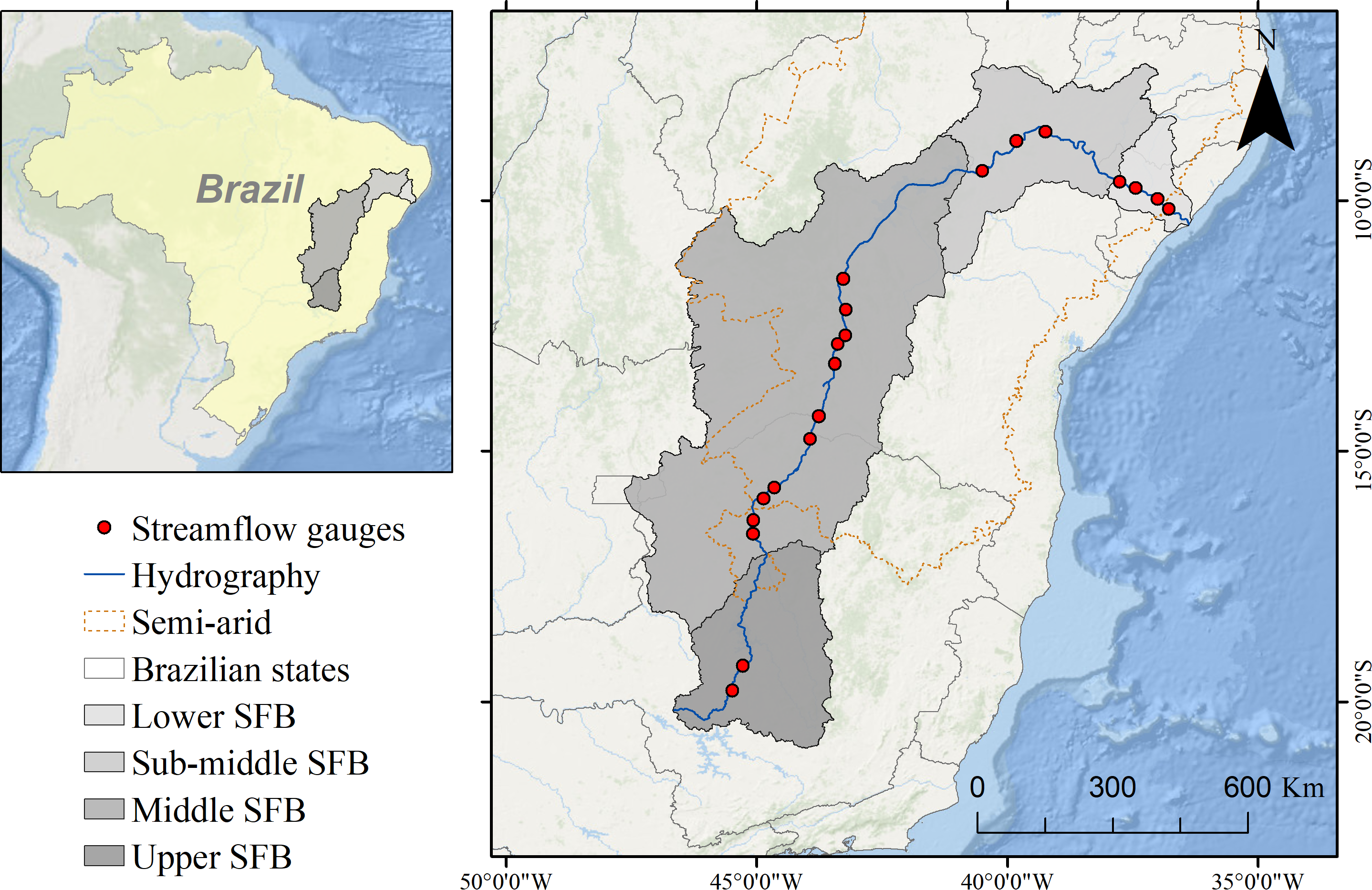
Water scarcity is a key challenge to global development. In Brazil, the Sao Francisco River Basin (SFB) has experienced water scarcity problems because of decreasing streamflow and increasing demands from multiple sectors (e.g., food and energy production and urban supply). However, the drivers of decreased streamflow, particularly the potential role of groundwater withdrawals, have not been yet investigated. Here, we assess long-term trends in baseflow, quickflow, and streamflow of the SFB during 1980–2015 and constrain the most likely drivers of observed decreases through trend analysis of precipitation (P), evapotranspiration (ET), and terrestrial water storage change (TWS). We found that over 82% of the observed decrease in streamflow can be attributed to a significant decreasing baseflow trend (< -20 m3 s-1 y-1) along the SFR with spatial agreement between decreased baseflow, increased ET, and irrigated agricultural land. We also found a decrease in TWS across the SFB with trends exceeding -20 mm y-1. Overall, our findings indicate that decreasing groundwater contributions (i.e., baseflow) are the primary cause of the observed reduction in total SFR flow. A lack of significant climate trends indicates that climate variability likely has not caused the observed baseflow reduction, mainly in the Middle and Sub-middle SFB, and therefore groundwater and surface withdrawals may be the most likely driver of water scarcity over the SFB. We call for increased attention on groundwater’s key role for the SFB and integrated regional management of surface and groundwater.