Xiaohua Huang

and 2 more

Deuterated water has been applied in hydrogeological tracer tests in recent years. However, there is a contradiction about the conservativeness of artificial deuterium (D/2H). In this study, what circumstances HDO behaved truly conservatively were investigated through laboratory-scale experiments via comparing the widely used tracer chloride (Cl-). And reasons for the non-conservativeness of HDO were discussed comprehensively for the first time. In addition, the advection-dispersion equation (ADE) and dual-domain mass transfer (DDMT) equation were employed to describe the breakthrough curves (BTCs) of tracers. HDO behaved conservatively when it transported in the porous media with high permeability (approximately K > 1m/d), and ADE could describe BTCs successfully. While hysteresis effect of HDO expressed in the media with low permeability. And the lower the permeability of the porous media, the stronger the hysteresis effect. DDMT was more suitable for demonstrating BTCs in low permeability media. Hydrogen bonds between HDO and H2O, the isotopic exchange effect, and the dual-domain model of the media all could lead to the hysteresis effect. The retardation factor (R = 1.72) was used to describe transporting behaviors of HDO in clay firstly. And the threshold hydraulic conductivity (Kcr) and the proportion of immobile regions of HDO were greater than that of Cl-, while dispersion coefficients of HDO were smaller. These could provide further considerations for using deuterium in hydrogeological tracer tests.

Pengfei Gu

and 6 more

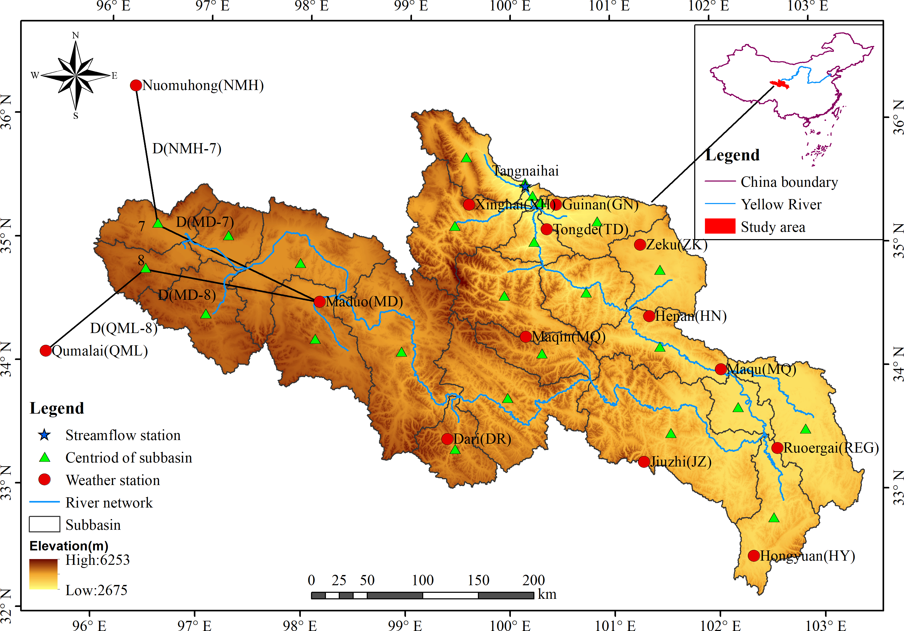
Alpine basins are essential to the conservation of water resources. However, they are typically poorly gauged and inaccessible, owing to the harsh prevailing environment and complex terrain. To investigate the influences of different precipitation inputs on hydrological modeling in alpine basins, two representative satellite precipitation products [Tropical Rainfall Measuring Mission (TRMM) and Integrated Multi-Satellite Retrievals for GPM (IMERG)] and two reanalysis precipitation products [China Meteorological Assimilation Driving Datasets for the SWAT model (CMADS) and Climate Forecast System Reanalysis (CFSR)] in the Yellow River Source Region (YRSR) were selected for evaluation and hydrological verification against gauge-observed data (GO). Results indicates that the accuracy of these precipitation products in the warm season is higher than that in the cold season, and IMERG has the best performance, followed by CMADS, CFSR, and TRMM. TRMM seriously overestimates high rainfall of greater than 10 mm/day. CFSR overestimates moderate precipitation events of 1–10 mm/d, while CMADS underestimates the effects of precipitation events of 1–20 mm/d. Models using the GO as input yielded satisfactory performance during 2008–2013, and precipitation products have poor simulation results. Although the model using IMERG as input yielded unsatisfactory performance during 2014–2016, this did not affect the use of IMERG as a potential data source for YRSR. After bias correction, the quality of CFSR improves significantly with R2 and NSE increasing by 0.25 and 0.31 at Tangnaihai station, respectively. Model driven by the combination of GO and CMADS precipitation performed the best in all scenarios (R2 = 0.77, NSE = 0.72 at Tangnaihai station; R2 = 0.53, NSE = 0.48 at Jimai station). These results can provide reference data, and research ideas, for improved hydrological modeling of alpine basins.

Pengfei Gu

and 8 more

Reanalysis meteorological datasets have been widely used for hydrological simulation research in areas where meteorological stations are scarce. However, most of them focus on the applicability of datasets to basin or hydrological model and pay little attention to the influence of meteorological elements of dataset on hydrological modeling. In this study, the precipitation, temperature and solar radiation from three meteorological datasets, gauge dataset (GD), the China Meteorological Assimilation Driving Datasets for the Soil and Water Assessment Tool (SWAT) model (CMADS), and Climate Forecast System Reanalysis (CFSR), were cross-combined with multiple scenarios to drive SWAT models in Yellow River Source Region (YRSR). After a comprehensive comparison of all the scenarios, the main conclusions are as follows: (1) replacing precipitation data has a large impact on streamflow simulation of SWAT model, and using observed precipitation from sparse stations consistently yielded better performance than using precipitation from CMADS and CFSR. (2) In the scenarios adopting observed precipitation as input, using temperature from CMADS and CFSR datasets yielded better performance than using observed temperature. (3) replacing solar radiation has slight impact on the streamflow simulation, and the solar radiation of CFSR is more suitable for hydrological simulation than that of CMADS in YRSR. (4) the SWAT model driven by different meteorological datasets shows that the runoff simulation of GD with CFSR solar radiation data (S6) is optimal with “very good” performance, while the simulation performance of CMADS and CFSR are poor with clearly underestimation for CMADS and significantly overestimation for CFSR, especially in the dry season. These result indicated that the element combination method of the meteorological dataset has been proven to be useful in YRSR, which provides a new insight for hydrological simulation research in areas where meteorological stations are scarce.