Nick Bouskill

and 17 more

Mountainous watersheds are characterized by variability in functional traits, including vegetation, topography, geology, and geomorphology, which together determine nitrogen (N) retention, and release. Coal Creek and East River are two contrasting catchments within the Upper Colorado River Basin that differ markedly in total nitrate (NO3-) export. The East River has a diverse vegetation cover, sinuous floodplains, and is underlain by N-rich marine shale, resulting in a three to twelve times greater total NO3- export relative to the conifer-dominated Coal Creek. While this can partly be explained by the larger size of the East River, the distinct watershed traits of these two catchments imply different mechanisms controlling the aggregate N-export signal. A causality analysis shows biogenic and geogenic processes were critical in determining NO3- export from the East River catchment. Stable isotope ratios of NO3- (δ15NNO3 and δ18ONO3) show the East River catchment is a strong hotspot for biogeochemical processing of NO3- at the soil-saprolite interface and within the floodplain prior to export. By contrast, the conifer-dominated Coal Creek retained nearly all (~97 %) atmospherically-deposited NO3-, and its export was controlled by catchment hydrological traits (i.e., snowmelt periods and water table depth). The conservative N-cycle within Coal Creek is likely due to the abundance of conifer trees, and a smaller riparian region, retaining more NO3- overall and reduced processing prior to export. This study highlights the value of integrating isotope systematics to link watershed functional traits to mechanisms of watershed element retention and release.

Nicholas A Sutfin

and 6 more

Changes in the magnitude and frequency of river flows have potential to alter sediment dynamics and morphology of rivers globally, but the direction of these changes remains uncertain. A lack of data across spatial and temporal scales limits understanding of river flow regimes and how changes in these regimes interact with river bank erosion and floodplain deposition. Linking characteristics of the flow regime to changes in bank erosion and floodplain deposition is necessary to understand how rivers will adjust to changes in hydrology from societal pressures and climatic change, particularly in snowmelt-dominated systems. We present a lidar dataset, intensive field surveys, aerial imagery and hydrologic analysis spanning 60 years, and spatial analysis to quantify bank erosion, lateral accretion, floodplain overbank deposition, and a floodplain fine sediment budget in an 11-km long study segment of the meandering gravel bed East River, Colorado, USA. Stepwise regression analysis of channel morphometry in nine study reaches and snowmelt-dominated annual hydrologic indices in this mountainous system suggest that sinuosity, channel width, recession slope, and flow duration are linked to lateral erosion and accretion. The duration of flow exceeding baseflow and the slope of the annual recession limb explain 59% and 91% of the variability in lateral accretion and erosion, respectively. This strong correlation between the rate of change in river flows, which occurs over days to weeks, and erosion suggests a high sensitivity of sedimentation along rivers in response to a shifting climate in snowmelt-dominated systems, which constitute the majority of rivers above 40° latitude.

Abhinav Gupta

and 2 more

A variety of watershed responses to climate change are expected due to non-linear interactions between various hydrologic processes acting at different timescales that are modulated by watershed properties. Changes in statistical structure (spectral properties) of streamflow in the USA due to climate change were studied for water years 1980-2013. The Fractionally differenced Autoregressive Integrated Moving Average (FARIMA) model was fit to the deseasonalized streamflow time-series to model its statistical structure. FARIMA allows the separation of streamflow into low frequency (slowly varying) and high frequency (fast varying) components. Results show that in snow dominated watersheds, the contribution of low frequency components to total streamflow variance has decreased over the study period, and the contribution of high frequency components has increased. The change in snow dominated watersheds was primarily driven by changes in rainfall statistics and changes in snow water equivalent but also by changes in seasonal temperature statistics. Among rain-driven watersheds, the contribution of high frequency components generally increased in arid regions but decreased in humid regions. In both humid and arid rain-driven watersheds, increasing winter temperature was responsible for the change in streamflow regimes. These results have consequences for predictability of streamflow in the presence of climate change. We expect that changes in the high frequency component will result in poorer predictability of streamflow.
Deeper flows through bedrock in mountain watersheds could be important but lack of data to characterize bedrock properties and link flow paths to snow-dynamics limits understanding. To address data scarcity, we combine a previously published integrated hydrologic model of a snow-dominated, headwater basin with a new method for dating baseflow age using dissolved gas tracers SF, N, Ar. The original flow model produces shallow groundwater flow (median depth 6 m), very young stream water and is unable to reproduce observed SF concentrations. To match the observed gas data, bedrock permeability is increased to allow a larger fraction of deeper groundwater flow (median depth 110 m). Results indicate that interannual variability in baseflow age (3-12 y) is dictated by the volume of seasonal interflow. Deeper groundwater flow remains stable (11.7±0.7 y) as a function of the ratio of recharge to bedrock hydraulic conductivity (R/K), where recharge is dictated by long-term climate and land use. With sensitivity experiments, we show that information gleaned from gas tracer data to increase bedrock hydraulic conductivity effectively moves this alpine basin away from shallow, topographically controlled groundwater flow with baseflow age relatively insensitive to water inputs (high R/K), and closer toward recharge-controlled conditions, in which a small shift toward a drier future with less snow accumulation will alter the groundwater flow system and increase baseflow age (low R/K). Work stresses the need to explore alternative methods characterizing bedrock properties in mountain basins to better quantify deeper groundwater flow and predict their hydrologic response to change.
Stable isotopes of water are important tracers in hydrologic research for understanding water partitioning between vegetation, groundwater, and runoff, but are rarely applied to large watersheds with persistent snowpack and complex topography. We combined an extensive isotope dataset with a coupled hydrologic and snow isotope fractionation model to assess mechanisms of isotopic inputs into the soil zone and implications on recharge dynamics within a large, snow-dominated watershed of the Upper Colorado River Basin. Results indicate seasonal isotopic variability and isotope lapse rates of net precipitation are the dominant control on isotopic inputs to the basin. Snowpack fractionation processes account for <5% annual isotope influx variability. Isotopic fractionation processes are most important in the shrub-dominated upper montane. Effects of isotopic fractionation are less important in the low-density conifer forests of the upper subalpine due to vegetative shading, low aridity, and a deep, persistent snowpack that buffers small sublimation losses. Melt fractionation can have sub-seasonal effects on snowmelt isotope ratios with initial snowmelt depleted but later snowmelt relatively enriched in heavy isotopes through the isotopic mass balance of the remaining snowpack, with the efficiency of isotopic exchange between ice and liquid water declining as snow ablation progresses. Hydrologic analysis indicates maximum recharge in the upper subalpine with wet years producing more isotopically depleted snowmelt (1-2‰ reduction in d18O) through reduced aridity when energy-limited. The five-year volume-weighted d18O in this zone (18.2±0.4‰) matches groundwater observations from multiple deep wells, providing evidence that the upper subalpine is a preferential recharge zone in mountain systems.

Zarine Kakalia

and 13 more

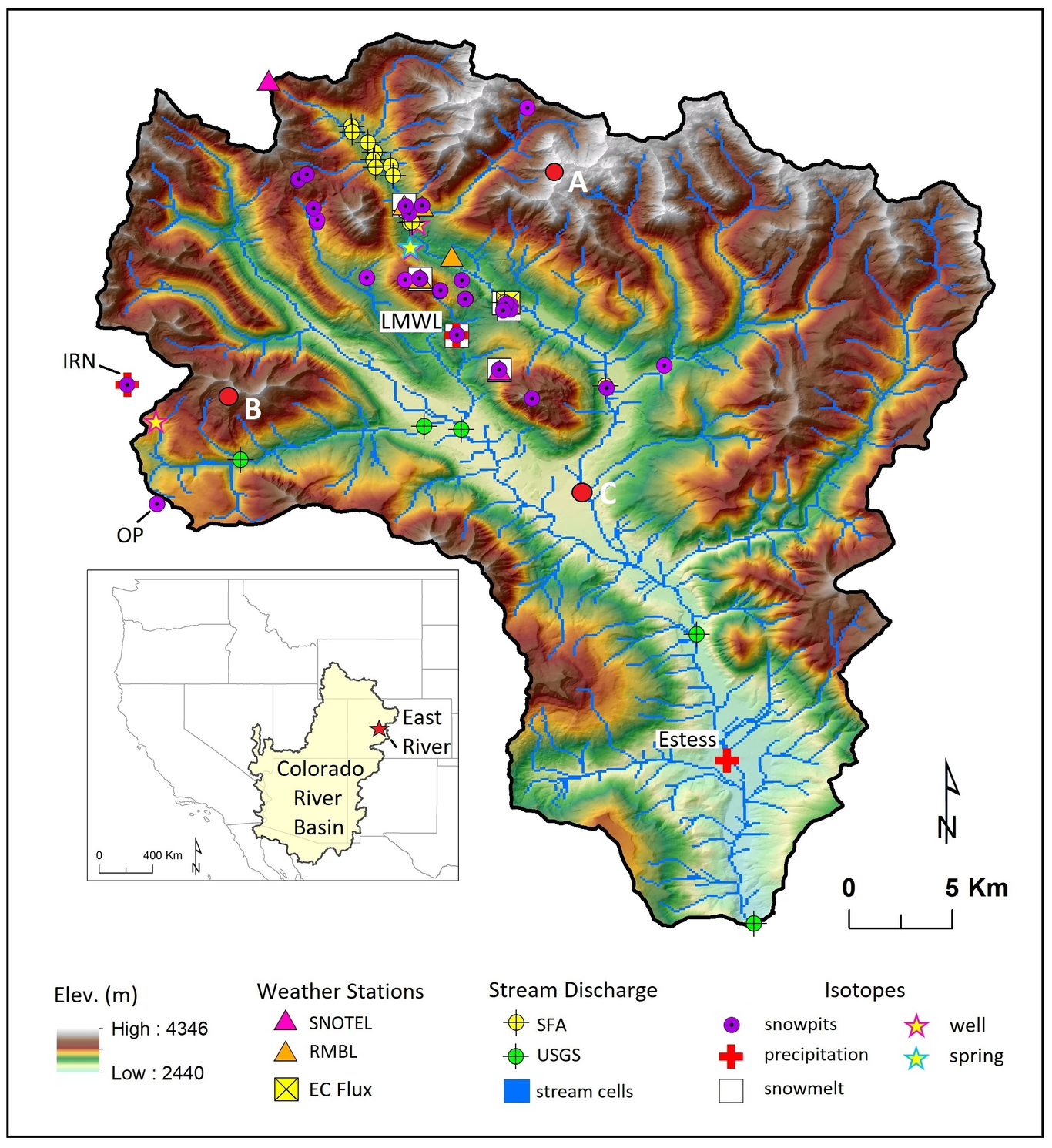
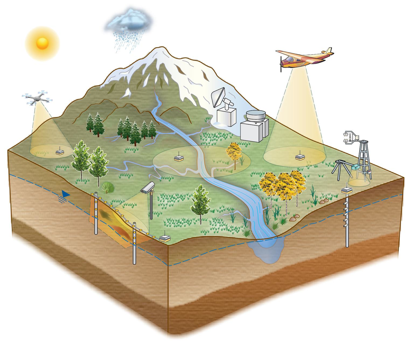
The U.S. Department of Energy’s (DOE) East River community observatory (ER) in the Upper Colorado River Basin was established in 2015 as a representative mountainous, snow-dominated watershed to study hydrobiogeochemical responses to hydrological perturbations in headwater systems. Led by the Watershed Function Science Focus Area (SFA), the ER has both long-term and spatially-extensive observations paired with experimental campaigns. The Watershed Function SFA, led by Berkeley Laboratory, includes researchers from over 30 organizations who conduct cross-disciplinary process-based investigations and mechanistic modeling of watershed behavior in the ER. The data generated at the ER are extremely heterogeneous, and include hydrological, biogeochemical, climate, vegetation, geological, remote sensing, and model data that together comprise an unprecedented collection of data and value-added products within a mountainous watershed, across multiple spatiotemporal scales, compartments, and life zones. Within 5 years of data collection, these datasets have already revealed insights into numerous aspects of watershed function such as factors influencing snow accumulation and melt timing, water balance partitioning, and impacts of floodplain biogeochemistry and hillslope ecohydrology on riverine geochemical exports. Data generated by the SFA are managed and curated through its Data Management Framework. The SFA has an open data policy, and over sixty ER datasets are publicly available through relevant data repositories. A public interactive map of data collection sites run by the SFA is available to inform the broader community about SFA field activities. Here, we describe the ER and the SFA measurement network, present the public data collection generated by the SFA and partner institutions, and highlight the value of collecting multidisciplinary multiscale measurements in representative catchment observatories.