The forest-floor litter layer can retain substantial volumes of water, thus affecting evaporation and soil-moisture dynamics. However, litter layer wetting/drying dynamics are often overlooked when estimating forest water budgets. Here, we present field and laboratory experiments characterizing water cycling in the forest-floor litter layer and outline its implications for subcanopy microclimatic conditions and for estimates of transpiration and recharge. Storage capacities of spruce needle litter and beech broadleaf litter averaged 3.1 and 1.9 mm, respectively, with drainage/evaporation timescales exceeding 2 days. Litter-removal experiments showed that litter reduced soil water recharge, reduced soil evaporation rates, and insulated against ground heat fluxes that impacted snowmelt. Deadwood stored ~0.7 mm of water, increasing with more advanced states of decomposition, and retained water for >7 days. Observed daily cycles in deadwood weight revealed decreasing water storage during daytime as evaporation progressed and increasing storage at night from condensation or absorption. Water evaporating from the forest-floor litter layer modulates the subcanopy microclimate by increasing humidity, decreasing temperature, and reducing VPD. Despite the relatively small litter storage capacity (<3.1 mm in comparison to ~102 mm for typical forest soil rooting zones), the litter layer alone retained and cycled 18% of annual precipitation, or 1/3 of annual evapotranspiration. These results suggest that overlooking litter interception may lead to substantial overestimates of recharge and transpiration in many forest ecosystems.

Tobias Nicollier

and 4 more

The spatio-temporal variability of bedload transport processes poses considerable challenges for bedload monitoring systems. One such system, the Swiss plate geophone (SPG), has been calibrated in several gravel-bed streams using direct sampling techniques. The linear calibration coefficients linking the signal recorded by the SPG system to the transported bedload can vary between different monitoring stations by about a factor of six, for reasons that remain unclear. Recent controlled flume experiments allowed us to identify the grain-size distribution of the transported bedload as a further site-specific factor influencing the signal response of the SPG system, along with the flow velocity and the bed roughness. Additionally, impact tests performed at various field sites suggested that seismic waves generated by impacting particles can propagate over several plates of an SPG array, and thus potentially bias the bedload estimates. To gain an understanding of this phenomenon, we adapted a test flume by installing a partition wall to shield individual sensor plates from impacting particles. We show that the SPG system is sensitive to seismic waves that propagate from particle impacts on neighboring plates or on the concrete bed close to the sensors. Based on this knowledge, we designed a filter method that uses time-frequency information to identify and eliminate these “apparent” impacts. Finally, we apply the filter to four field calibration datasets and show that it significantly reduces site-to-site differences between calibration coefficients and enables the derivation of a single calibration curve for total bedload at all four sites.

Liang Zhang

and 7 more

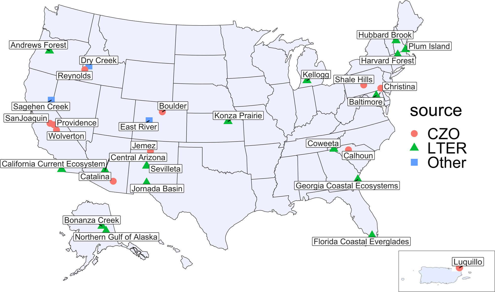
Hydrological analyses and their associated uncertainties are a function of their supporting observational datasets. Publicly available large-sample hydrology datasets covering a range of climates, times, and locations can be used to support inter-watershed comparisons, pattern identification, and watershed regionalization studies. However, most of the large-sample datasets are limited to a series of basic measurements such as precipitation, air temperature, and streamflow. Here we synthesized data from 30 intensively monitored catchments with soil moisture, snowmelt, and other hydrometeorological observations at daily scale across the US. This data synthesis product, CHOSEN (CONUS/Comprehensive Hydrologic Observatory SEnsor Network), includes watersheds from the Long-Term Ecological Research (LTER) and Critical Zone Observatory (CZO) networks, and several other ecological and hydrological observatories. Catchments span diverse climate gradients and encompass multiple biomes and ecosystems. To achieve a consistent and standardized data product, we first implemented data cleaning and control procedures with strict variable naming conventions and unit conversions. Following data quality control, data processing methods, including gap filling by interpolation, linear regression, and climate catalog-based techniques, were implemented to produce alternative level-2 products. The data and metadata were written into self-describing NetCDF files, facilitating ease of access by multiple computer platforms. All python coding scripts, ranging from processing to accessing the NetCDF files, are publicly available, along with a user-friendly tutorial. The standardizations adopted here, and the availability of the data-processing pipeline, will facilitate future additions of new observations to this database. We anticipate that this synthesis will support comparative long-term hydrological studies and contribute to a growing body of open-source research in watershed and ecosystem science.