Biqing Tian

and 3 more

Lake has an essential role in Earth’s hydrologic cycle. The changing of lake water areas shows the ecological health of lakes by instant feedback. Remote sensing monitoring reflects the changes in lake water intuitively. This study, based on remote sensing, combined with the hydrological data, meteorological data, and land use survey, investigated the Poyang lake water area changes from 1977 to 2021. Examined the relationship between the lake water area and the impact factor and analyzed the influence of river lake interaction on the lake water area. The results showed that: (1) From 1977 to 2017, the water area of Poyang Lake in flood season (June to September) and dry season (November to Next February) showed a significant downward trend by years. (2) In flood season, runoff, sediment, and precipitation significantly correlate with a water area. In the dry season, sediment significantly correlated with a water area. (3) The Three Gorges Dam water impoundment at the upper reaches of the Yangtze River weakened and eliminated the block and reverse flow of the Yangtze River on Poyang lake, causing the water area to decrease in advance at the end of the flood season after 2005, and decrease rapidly in the dry season after 2003. (4) The change in lakebed elevation caused by sedimentation and human activities also accelerated the shrinkage of the water area. Results demonstrated that the variation of river lake interaction is the primary cause of the Poyang Lake water area’s dramatic change.

Biqing Tian

and 3 more

Lake has an important role of Earth’s hydrologic cycle. The changing of lake water area shows the ecological health of lakes by instant feedback. Most analyses of long-term monitoring of lake area are not comprehensive enough, This study based on the remote sensing images from 1977 to 2021, combined with the Keyhole satellite data, hydrographic survey, meteorology monitoring and land use change survey, investigated the Poyang lake water area changes. Moreover, examined the response relationship between lake water area and the impact factor, analyzed the influence of river lake interaction on lake water area.The results showed that: (1) From 1977 to 2017, the water area of Poyang Lake in flood season (June to September) and dry season (November to Next February) showed a significant downward trend by years. (2) In flood season, runoff, sediment, precipitation has significant correlation with water area. In dry season, sediment showed a significant correlation with water area. (3) The Three Gorges Dam water impoundment at the upper reaches of the Yangtze River weakened eliminated the blocking or reversing flow from the Yangtze River, caused the water area decreased in advance at the end of flood season after 2005, and decreased rapidly in dry season after 2003. (4) The change of lakebed elevation caused by sedimentation and human activities also accelerated the shrinkage of water area. Result demonstrated that the variation of river lake interaction is the primary cause of Poyang Lake water area dramatic change.

dexun Qiu

and 3 more

Soil moisture is essential for vegetation restoration in arid and semi-arid regions. Ascertaining the vertical distribution and transportation of soil moisture under different vegetation restoration types has a profound impact on the ecological construction. In this study, the soil moisture at a depth of 500 cm for four typical vegetation types, including R. pseudoacacia (forestland), C. korshinskii (shrubland), S. bungeana (abandoned land), and corn (cropland) were investigated and compared in the Zhifanggou watershed of Loess plateau, China. Additionally, hydrogen and oxygen stable isotopes were detected to identify and reflect the characteristics of soil water. The results showed vertical distribution and transportation of soil moisture have different variations under different vegetation types. Depth-averaged soil moisture under S. bungeana and corn increased along the profile as a whole, while C. korshinskii and R. pseudoacacia showing a trend of weakly increasing and relatively stable state after an obvious decreasing trend (0–40 cm). The mean soil moisture under R. pseudoacacia is lower than other types, especially in deeper layers. In addition, it was observed that the longer vegetation age, the lower mean soil moisture, while this phenomenon was unobvious in S. bungeana. Planting arbor species such as R. pseudoacacia intensified the decline of soil moisture in the Loess Plateau, this limited the growth of arbor species in turn. The capacity of evaporation fractionation of soil moisture followed the sequence: corn > S. bungeana > R. pseudoacacia > C. korshinskii. Profiles of δ18O values of soil moisture under different vegetation types are quite different. On the whole, the δ18O values varied greatly in upper soil layers and tend to be consistent with the increase of soil depth. We estimate that piston flow is the main mode of precipitation infiltration, and the occurrence of preferential flow is related to vegetation types. These results are expected to help improve the understanding of the response of deep soil moisture to vegetation restoration and inform practices for sustainable water management.

Changxue Wu

and 5 more

Wei River is the largest tributary of the Yellow River, and in recent decades, water resource has changed significantly. Identifying the characteristics and influencing factors of streamflow change in Wei River is needed for development of effective management strategies and economic development for the region and entire Yellow River basin. The analyzations were based on streamflow records from 1957 to 2018 at five hydrological stations as well as precipitation and air temperature data from 22 meteorological stations. Mann-Kendall method and Pettitt test were used to analyze trends and transition years of hydrometeorological variables. Double mass curves (DMC) were used to quantify the impact of climate changes and anthropogenic activities on streamflow change. The results showed that: the annual average streamflow decreased significantly in the upper reaches (URWR), middle reaches (MRWR) of the main Wei River, Jing River Basin (JRB), Beiluo River Basin (BLRB) as well as the whole Wei River Basin (WWRB). There were transition years existed in these reaches and concentrated in 1990s. The annual precipitation showed a significant downward trend in the MRWR, LRWR, BLRB and WWRB (P<0.01). Air temperature in all reaches rise significantly (P<0.01). Analysis of land use from 1980 to 2020 indicated that residential land and grassland increased markedly. The results of DMC showed that anthropogenic activities were the dominant factors for streamflow reduction, accounting for 52.96%-92.2%. For different reaches, the intensity of human activities (domestic water, agricultural irrigation, industrial water, soil and water conservation measures and reservoirs construction, etc.) was different, resulting in the difference of contribution rate. Relevant research results provide basis for scientific regulation of water resources in Wei River Basin.

yu luo

and 2 more

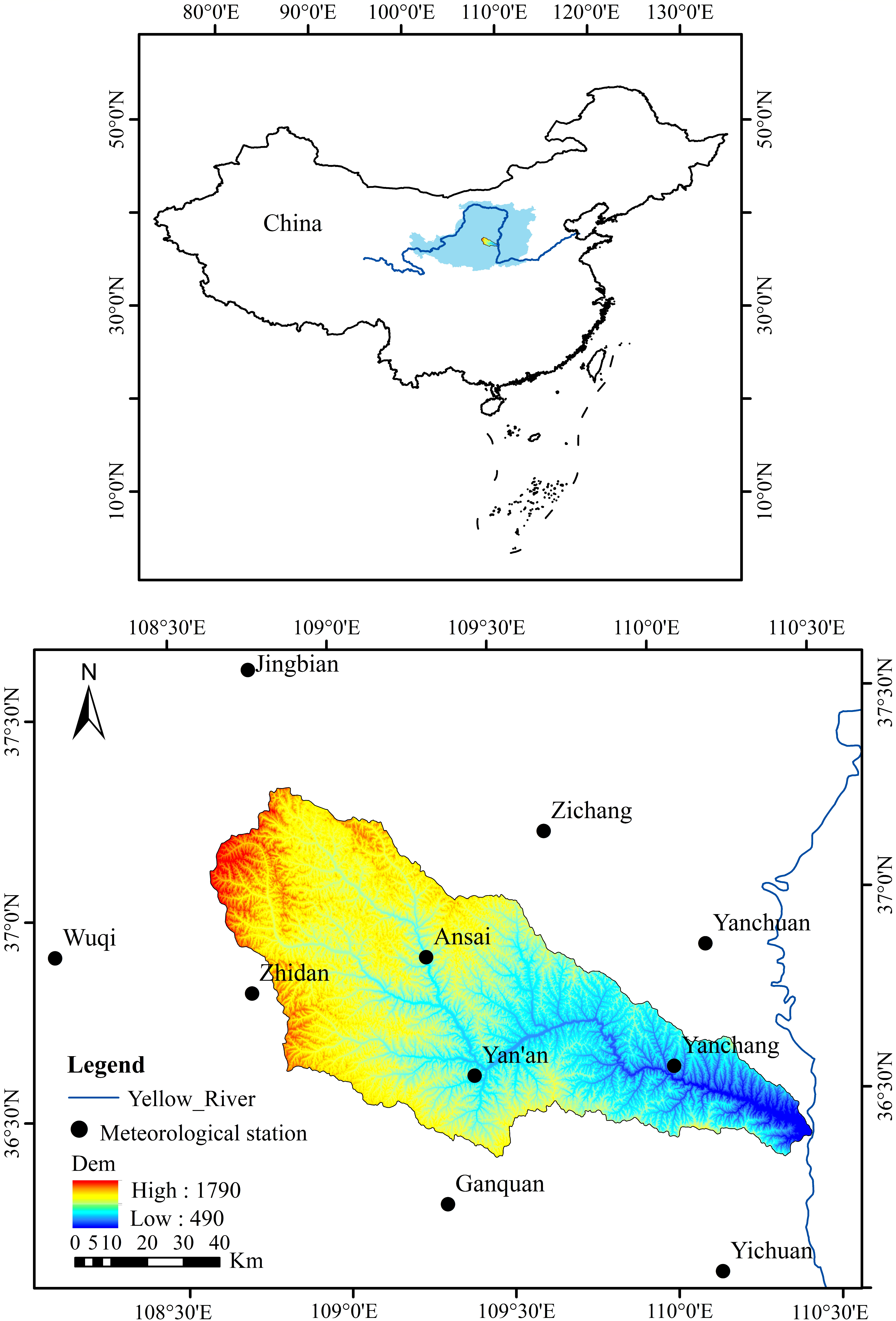
Potential evapotranspiration (ET0) is an essential component of the hydrological cycle, and quantitative estimation of the influence of meteorological factors on ET0 can provide a scientific basis for studying the impact mechanisms of climate change. In the present research, the Penman-Monteith method was used to calculate ET0. The Mann-Kendall statistical test with the inverse distance weighting were used to analyze the spatiotemporal characteristics of the sensitivity coefficients and contribution rates of meteorological factors to ET0 to identify the mechanisms underlying changing ET0 rates. The results showed that the average ET0 for the Yanhe River Basin, China from 1978–2017 was 935.92 mm. Save for a single location (Ganquan), ET0 increased over the study period. Generally, the sensitivity coefficients of air temperature (0.08), wind speed at 2 m (0.19), and solar radiation (0.42) were positive, while that of relative humidity was negative (-0.41), although significant spatiotemporal differences were observed. Increasing air temperature and solar radiation contributed 1.09% and 0.55% of the observed rising ET0 rates, respectively; whereas decreasing wind speed contributed -0.63%, and relative humidity accounted for -0.85%. Therefore, it was concluded that the decrease of relative humidity did not cause the observed ET0 increase in the basin. The predominant factor driving increasing ET0 was rising air temperatures, but this too varied significantly by location and time (intra- and interannually). Decreasing wind speed at Ganquan Station decreased ET0 by -9.16%, and was the primary factor underlying the observed, local “evaporation paradox.” Generally, increases in ET0 were driven by air temperature, wind speed and solar radiation, whereas decreases were derived from relative humidity.

yu luo

and 3 more

Potential evapotranspiration (ET0) is an important expenditure item in the hydrological cycle. Quantitative estimation of the influence of meteorological factors on ET0 can provide a scientific basis for the study of the impact mechanism of climate change on the hydrological cycle. In this paper, the Penman-Monteith method was used to calculate ET0. The Mann-Kendall statistical test and the Inverse Distance Weighting method were used to analyze the temporal and spatial characteristics of the sensitivity coefficient of ET0 to meteorological factors and contribution rate of meteorological factors to ET0. And the reasons for the change of ET0 were quantitatively explored in combination with the change trend of meteorological factors. The results showed that the average ET0 in the Yanhe River Basin from 1978 to 2017 was 935.92mm. Except for Ganquan Station, ET0 showed an upward trend. Generally, the sensitivity coefficient of air temperature (0.08), wind speed (0.19) and solar radiation (0.42) was positive and the sensitivity coefficient of relative humidity (-0.41) was negative. But there were significant temporal and spatial differences. The upward trend of air temperature and solar radiation contributed 1.09% and 0.55% to ET0. Respectively, the downward trend of wind speed contributed -0.63% And the downward trend of relative humidity contributed to -0.85% of ET0. Therefore, the decrease of relative humidity did not cause the increase of ET0 in Yanhe River basin. The dominant factor of the upward trend of ET0 was air temperature. But the dominant factors of ET0 had significant temporal and spatial differences. The downward trend of wind speed at Ganquan Station contributed -9.16% to ET0, which indicated the dominant factor of “evaporation paradox” in Ganquan area was wind speed. Generally, the increase of ET0 was related to air temperature, wind speed and solar radiation. And the decrease of ET0 was related to relative humidity.