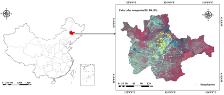
Electrical conductivity (EC) is not only an important index to evaluate the degree of soil salinization, but also an essential basis for judging whether saline soil can be improved and assess the effect of improvement efforts. Satellite remote sensing provides much information for large scale EC inversion of saline soil, which enables the possibility for evaluating the degree and distribution of soil salinization. Taking the salinized region of western Jilin Province as the study area, 328 salinized soil samples were collected, and the EC was measured in June 2019. The construction of the optimal spectral parameters was based on the correlation between the conductivity and the spectral reflectivity of Sentinel-2 MSI data; after satisfying the normal distribution for the Box-Cox transformation of EC, the inversion model of EC was established by using linear regression model, support vector machine (SVM), regression tree (RT), Gaussian process regression (GPR), and ensemble tree (ET). The verification results of the model on the validation set showed that the performance of GPR was optimal (R2 = 0.66, RMSE = 0.48 mS/cm, MAE=0.52 mS/cm), which increased R2 by 29.04% compared with the traditional linear regression model. Finally, according to the GPR model, the EC results of pixel-level resolution (10 m × 10 m) of saline soil in western Jilin Province were inversed, which provided a scientific basis for the study of the distribution characteristics and improvement scheme of saline soil.