Aaron Smith

and 3 more

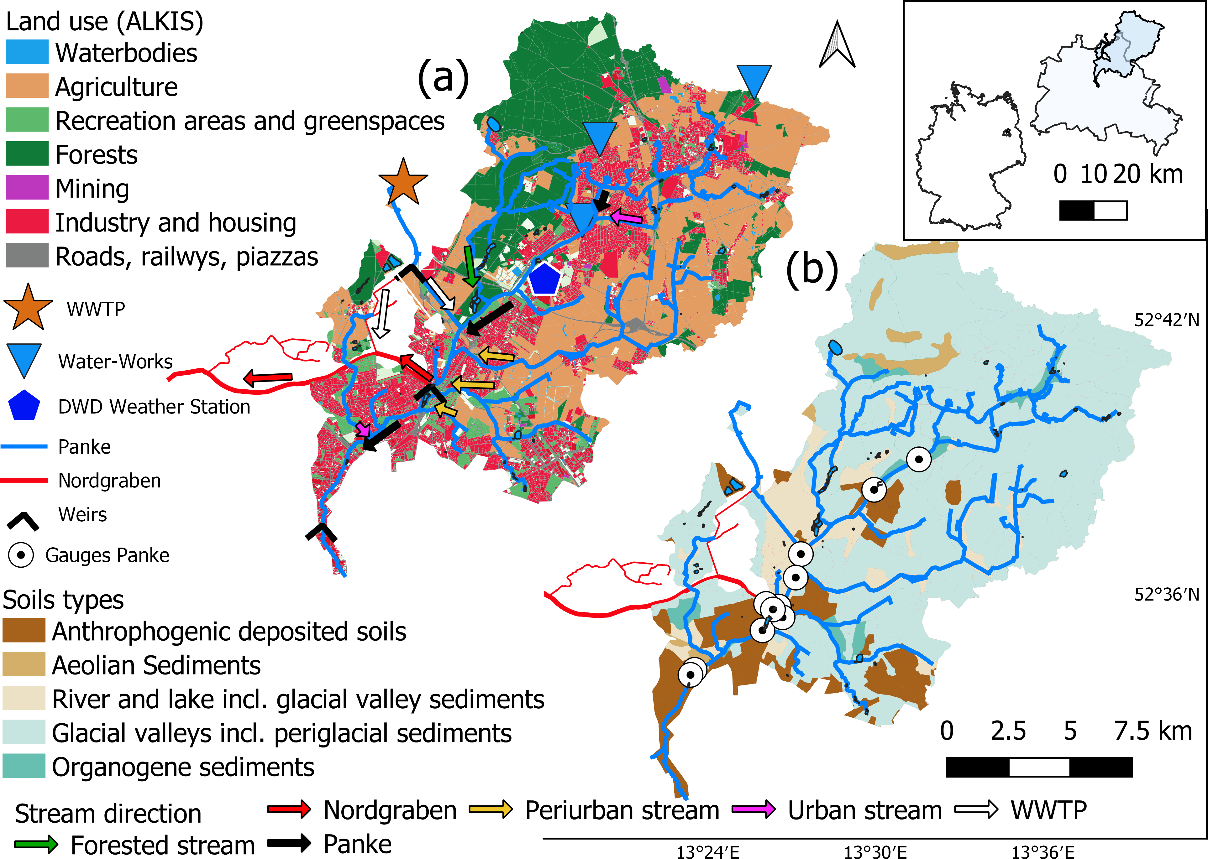
Increased urbanization, coupled with the projected impacts of climatic change, mandates further evaluation of the impact of urban development on water flow paths to guide sustainable land use planning. Though the general urbanization impacts of increased storm runoff peaks and reduced baseflows are well known; how the complex, non-stationary interaction of the dominant water fluxes within dynamic urban water stores sustain streamflow regimes over longer periods of time are less well quantified. In particular, there is a challenge in how hydrological modelling should integrate the juxtaposition of rapid and slower flow pathways of the urban ‘karst’ landscape and different approaches need evaluation. In this context, we utilized hydrological and water stable isotope datasets within a modelling framework that combined the commonly used HEC urban runoff model along with a simple hydrological tracer module and transit time modelling to evaluate the spatial and temporal variation of water flow paths and ages within a heavily urbanized 217km 2 catchment in Berlin, Germany. Deeper groundwater was the primary flow component within less urbanized regions of the catchments, with increased direct runoff and shallow subsurface contributions in more urbanized areas near the catchment outlet. The addition of wastewater effluent in the mid-reaches of the catchment was the dominant water supply to the lower stream, and sustained baseflows during the summer months. Water ages from each modelling approach imitated flow contributions and opportunity for mixing with subsurface storage; with older water and lower young water contributions in less urbanized sub-catchments and younger water and higher young water contributions in more urbanized regions. The results form a first step towards more integrated modelling tools for similar peri-urban catchments, given the potential limitations of more simple model frameworks. The results have broader implications for assessing the uncertainty in evaluating urban impacts on hydrological function under environmental change.

Christian Marx

and 3 more

Complex networks of both natural and engineered flow paths control the hydrology of streams in major cities through spatio-temporal variations in connection and disconnection of water sources. We used spatially extensive and temporally intensive sampling of water stable isotopes to disentangle the hydrological sources of the heavily urbanized Panke catchment (≈ 220 km²) in the north of Berlin, Germany. The isotopic data enabled us to partition stream water sources across the catchment using a Bayesian mixing analysis. The upper part of the catchment streamflow here is dominated by groundwater from gravel aquifers underlying surrounding agricultural land. In dry summer periods, streamflow becomes intermittent; possibly as a result of local groundwater abstractions. Urban storm drainage is also an important part of runoff generation, dominating the responses to precipitation events. Although this dramatically changes the isotopic composition of the stream, it only accounts for 10-15% of annual streamflow. Moving downstream, subtle changes in sources and isotope signatures occur as catchment characteristic vary and the stream is affected by different tributary inflows. However, effluent from a wastewater treatment plant (WWTP) serving 700,000 people dominates the stream in the lower catchment where urbanisation effects are more dramatic. The associated increase in sealed surfaces downstream also reduces the relative contribution of groundwater to streamflow. The volume and isotopic composition of storm runoff is again dominated by urban drainage. As a result, only about 10% of annual runoff in the lower catchment comes from urban storm drains. The study shows the potential of stable water isotopes as inexpensive tracers in urban catchments that can provide a more integrated understanding of the complex hydrology of major cities. This offers an important evidence base for guiding the plans to develop and re-develop urban catchments to protect, restore and enhance the ecological and amenity value of these important resources.