Boris Ochoa-Tocachi

and 2 more

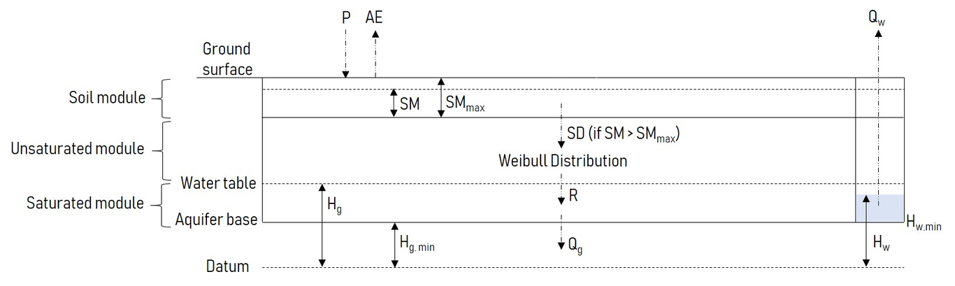
This year marks the centennial of the American Geophysical Union advancing Earth and space science and 89 years of hydrologic science. The last 100 years have seen science and technology dancing a harmonious and progressively accelerated waltz. Hydroelectric power generation has made widespread electrification possible, while the rise of electronics and the advent of computers have enabled hydrologists to exploit increasingly complex models. Scientists and engineers have conquered space, and now satellite-based products and remotely sensed data have become indispensable inputs for hydrometeorological forecasting. Yet several important elements that have accompanied humanity’s history – nature, culture, and people – have been relegated; and it is only very recently, in the face of modern challenges, that they have attracted substantial attention. The advent of robust, cheap, and low-maintenance sensing equipment provides unprecedented opportunities for data collection, especially in a citizen science context. While citizens have been present throughout the history of scientific practice, developments in sensing technology, data processing and visualization, and the communication of ideas and results, are creating a wide range of new opportunities for public participation in scientific research. Integrating societal knowledge with hydrologic science, however, is not only a task for the 21st century. Historically, many civilizations have developed local water harvesting and management practices that cope with water stress by using ancient and nature-based knowledge. Indeed, indigenous peoples developed solutions that were inspired and supported by nature, and use, or mimic, natural processes to contribute to improved water management and to safeguard their water security. Technological development and knowledge integration also have a more fundamental impact on the way in which hydrologic knowledge advances, how it flows between different actors, how it disrupts power relations, and thus how it influences decisions and policy-making. We envisage that, in the next century, hydrologic science will benefit from co-creating knowledge that emerges from citizens, resonates with nature, and integrates ancient wisdom.

William Veness

and 4 more

Drought Early Warning Systems (DEWSs) aim to spatially monitor and forecast risk of water shortage to inform early, risk-mitigating interventions. However, due to the scarcity of in-situ monitoring in groundwater-dependent arid zones, spatial drought exposure is inferred using maps of satellite-based indicators such as rainfall anomalies, soil moisture and vegetation indices. On the local scale, these coarse-resolution proxy indicators provide a poor inference of groundwater availability. The improving affordability and technical capability of modern sensors significantly increases the feasibility of taking direct groundwater level measurements in data-scarce, arid regions on a larger scale. Here, we assess the potential of in-situ monitoring to provide a localized index of hydrological drought in Somaliland. We find that calibrating a lumped groundwater model with a short time series of high-frequency groundwater level observations substantially improves the quantification of local water availability when compared to satellite-based indices over the same validation period. By varying the calibration length between 1-30 weeks, we find that data collection beyond 5 weeks adds little to model calibration at all three wells. This suggests that a short monitoring campaign is suitable to improve estimations of local water availability during drought, and provide superior performance compared to regional-scale satellite-based indicators. A short calibration period has practical advantages, as it allows for the relocation of sensors and rapid characterization of a large number of wells. A monitoring system with this contextualized, local information can support earlier financing and better targeting of early actions than regional DEWSs.

Alicia Correa

and 6 more

The páramos, a neotropical alpine grassland-peatland dominated biome of the northern Andes and Central America, play an essential role in regional and global cycles of water, carbon, and nutrients. They act as water towers, delivering water and ecosystem services mainly from the continental water divide at the Andean highland down to the Pacific and Amazon regions. The anthropogenic influence in form of the climate crisis exerts enormous pressures on these identified “hotspot” ecosystems and increases the vulnerability of nearby populations undermining the socio-economic and human development. Further, increasing pressures reduce the resilience to face climate shocks, and dramatically alters the hydro-climatic regime and shifts the páramos from long-term carbon sinks towards carbon sources. Despite their importance and vulnerability, only three decades ago, páramos, were globally among the least studied ecosystems. However, researchers have since identified them as ideal targets for solving water scarcity issues and to offset carbon emissions. Increasing awareness of the need for hydrological evidence to guide sustainable management of the páramos prompted action for generating data and to fill long-standing knowledge gaps. This has led to a remarkably successful community-research-policy effort to generate this knowledge. The combination of well-established and innovative approaches was used to data collection, processing and knowledge extraction. In this review, we provide a short overview of the state of knowledge of the hydrometeorology, flux dynamics, anthropogenic and the influence of extreme events in the regional páramos. Then, we present emerging technologies for hydrology and water resources research and management applied to páramos. Lastly, we discuss how converging science and policy efforts have leveraged traditional and new observational techniques to generate an evidence base that can support the sustainable management of the páramos. We conclude that this co-evolution of science policy was able to cover different spatial and temporal scales. Finally, we outline future research directions to showcase how sustainable long-term data collection can be sustained for the responsible development of páramo water towers.